
Editor’s note: Today’s blog post is a Q&A with Oliver Looker, Director of Transport and Smart Cities at NGIS and Dr. Evangelos Mitsakis, Research Director at CERTH. In this post they share how NGIS and agencies like CERTH are using comprehensive, real-time data from Roads Management Insights to make more informed decisions.
Q: Tell us about NGIS and how long you’ve been working with Google
Oliver Looker: We've been working with Google since 2011 and have been in operation now for over 30 years. Our core business is developing enterprise geospatial solutions. We’re focused on understanding the world around us and being able to use mapping data because when it comes to transport and traffic, it's effectively a location-based challenge.
Q: Explain how your solution TraceMark Flow works and how it leverages Google Maps Platform data
Oliver Looker: Transport agencies around the world face cost pressures in getting real time accurate up-to-date data. For example, several years ago we were working closely with the New South Wales government and the Roads and Maritime Services within Sydney. It was experiencing limitations on the data that they were using for travel time and an understanding of speed and network performance for their key roads and transport corridors. We worked to provide a contemporary solution that could be able to deliver on a whole range of use cases based on the complex nature of transport in terms of operations and planning. So from a solution perspective and to meet these requirements, we settled on maximizing the Google data and platforms. Over time we have built our own tools to deliver intelligence, and that's where we created TraceMark Flow.
Tracemark Flow combines the comprehensive, accurate, and timely data in Google Maps Platform with the scalability and power of Google Cloud, to provide a range of tools and use cases for operators and planners and to also integrate that within business ecosystems.
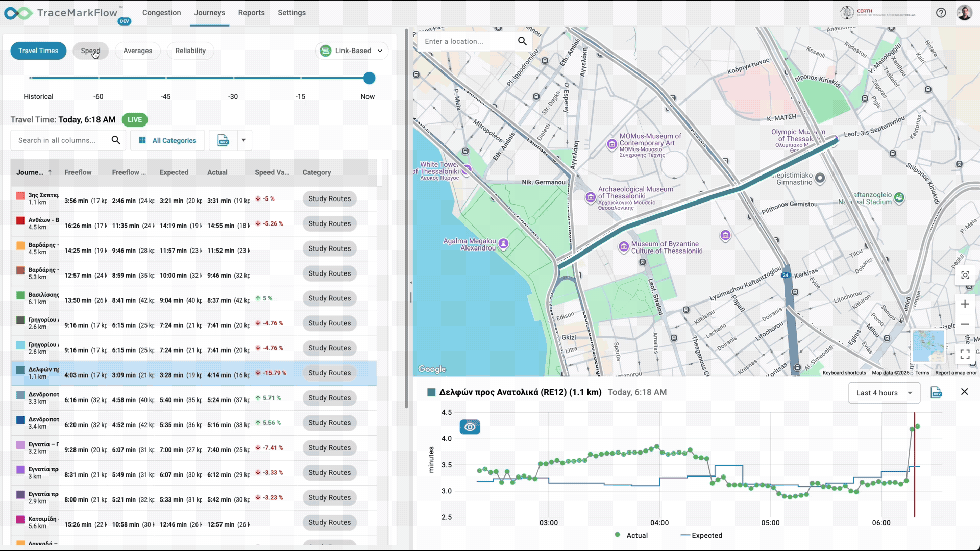
Real-time estimation of current travel time
Q: You’ve integrated Roads Management Insights into your TraceMark Flow solution. Why was this important?
Oliver Looker: Google launched Roads Management Insights in August and it's a revolutionary new tool using Google’s robust traffic data and safety information. We now have the ability to take all of that traffic pattern information from Google Maps Platform and give it to our customers—which means organizations can more efficiently manage roads and public utilities with both real time information, predictive information, and that leads to actionable insights that can help advance the outcomes. With Road Management Insights, agencies are able to look at trip durations, speed intervals, knowing where people are coming from and going to, and even road conditions in the future.
Q: Tell us about CERTH and the goals of the organization
Dr. Evangelos Mitsakis: CERTH is the national center for research and technology in Greece and is one of the top 10 research organizations in Europe. We’re made up of five separate research centers with more than 1,700 scientific and technical personnel publishing around 1,000 scientific papers per year. I represent the Hellenic Institute of Transport that was founded in 2000, which is the main transport research organization in Greece. Our objectives include the execution and promotion of advanced research covering all modes and domains of transport, support policy making and decision making for local, regional, and central governments, and to promote innovation in the transport domain.
Q: How are you leveraging TraceMark Flow and Google Maps Platform data in your work?
Dr. Evangelos Mitsakis: A primary activity of ours is related to research in traffic management. This includes multimodal traffic analytics, multisource data fusion and data quality, as well as developing large scale traffic simulation models. We also develop models to predict traffic conditions using recent AI technologies. Another important activity of ours in the traffic management domain is predicting risk for road accidents or crashes, also in development and provision of services for travelers. This includes traveler information services and route guidance services. And finally, we are also developing and deploying connected vehicle technologies and related services for citizens or specific fleets.
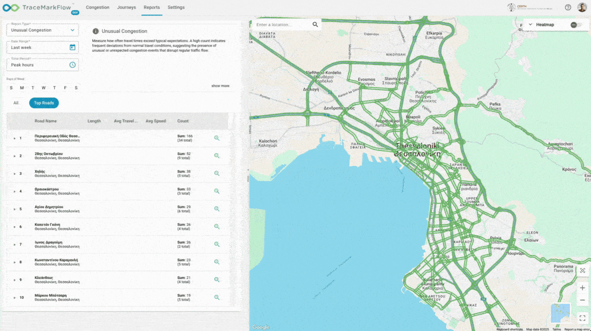
Analyzing and visualizing the concentration of unusual traffic congestion
Q: Can you tell us about any specific projects where you’re relying on TraceMark Flow?
Dr. Evangelos Mitsakis: For the past 2 years in Thessaloniki there has been a construction of an elevated motorway (the Flyover project) which aims to upgrade the capabilities and the capacity offered through the existing ring road of the city. It's approximately 13.5 km long with four traffic lanes per direction, three new tunnels and 10 elevated bridges. The goal of the project is to decrease congestion of the existing road infrastructure of the ring road and improve access to major infrastructures and areas near or around the city of Thessaloniki—including the airport as well as very popular holiday resort destinations around the city. It was critical for us to have the ability to measure the impacts before, during and after the construction.
Using TraceMark Flow and Roads Management Insights we were able to determine that we had 40 to 50% increased travel times in both directions east and west, compared to the period at the beginning of the project’s construction works, as well as a significantly reduced number of road accidents as a result of the new conditions during the construction. Armed with these insights we are able to communicate travel expectations to citizens. TraceMark Flow provided us with much more improved situational awareness to monitor key performance indicators both at the ring road directly impacted by the Flyover project construction works but also at major arterials inside the city of Thessaloniki.
Q: Have you experienced any other major impact or results?
Dr. Evangelos Mitsakis: Tracemark Flow and Roads Management Insights data has provided us with significantly improved prediction capabilities concerning short-term traffic forecasting. These tools have provided us with realtime information concerning the identification of congestion and bottlenecks. The tools have also provided us with increased capabilities to monitor alternative reliable routes and journeys for the citizens and the travelers of Thessaloniki during this construction period.
In addition, NGIS and Google have provided us with access to and use of high quality realtime traffic and travel data. In the end, this has resulted in a significantly improved situational awareness for our team and for the organizations responsible for traffic management. This has also improved decision making within the city resulting in significant redistribution of traffic flows and bottleneck avoidance for travelers.

