
Today we’re moving our Photorealistic 3D Tiles, 2D Tiles, and Street View Tiles into general availability, enabling developers to build immersive maps in production environments. You can access these features through the Map Tiles API.
Photorealistic 3D Tiles
Since our Experimental launch back in May 2023, developers across industries have used Photorealistic 3D Tiles to create powerful visual map experiences. While some are using Photorealistic 3D Tiles to illustrate future land developments with a realistic 3D backdrop, others are extending their 2D maps to 3D to help better communicate spatial patterns with more intuitive map views. Developers are also using Photorealistic 3D Tiles to create location-based AR experiences and to create branded immersive maps to drive customer engagement. Here are some applications developers have built:
Real estate and urban planning
BNP Paribas Real Estate, a European commercial property company, uses Photorealistic 3D Tiles to create a data visualization experience that shows today’s and tomorrow’s cities across Europe. The solution merges their own data and public open data to give a holistic view of the city to urban planners, investors, and commercial real estate customers. The visualization shows 3D cityscapes, overlaid with BNP Paribas Real Estate’s information about properties available on the market and local points of interest. It even shows how the city might change in the future based on transportation, building, and market forecasts. With this experience, BNP Paribas Real Estate hopes to give property customers and developers valuable market insights. They will continue adding geo datasets related to cities’ sustainability, demographic density, quality of life, housing, or economic landscape.
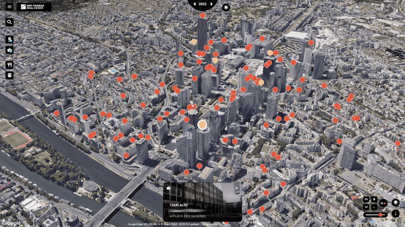
A 3D visualization of the city of Paris highlighting how the real estate landscape and the city infrastructure may change over time
Augmented reality (AR)
Alberto Taiuti, an augmented reality expert passionate about geospatial applications, used Photorealistic 3D Tiles to create a real-time guided tour editor of Florence, Italy from his browser. In the image below, you’ll see a demo of Alberto building the experience. On the left, Alberto is dropping pins on popular locations in Florence where they appear and move in real-time to help guide his brother (who’s there) using augmented reality**.** This image illustrates the viability of shared multiplayer map experiences that can connect people who are in different locations–even across the world. There are potential applications in gaming, tourism, or even site exploration for community development projects.
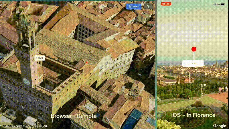
Demo of Alberto building the real-time guided tour editor of Florence, Italy from his browser
Architectural design
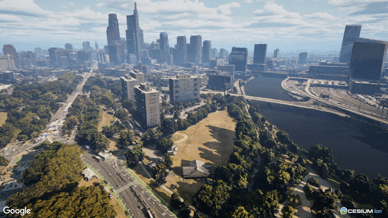
Geopogo, a software company that builds location-based AR tools for architectural and urban design workflows, is using Photorealistic 3D Tiles to give architects, urban planners, and commercial developers the ability to visualize their designs in cities around the world. Using Photorealistic 3D Tiles, Geopogo built a new feature for its latest update of the Magic Leap 2 AR glasses. They used the Tiles as an AR occlusion layer to visualize 3D AR building models in the real world. This update will enable architects, designers, and commercial developers to design, review, and showcase their building models in immersive visualizations onsite in see-through AR in the context of the real environment, rather than through traditional artistic renderings.
Compatible with a variety of renderers
You can use our Photorealistic 3D Tiles with your own renderer or other compatible renderers and visualization libraries, like CesiumJS and deck.gl because we’ve adopted the commonly-used Open Geospatial Consortium’s 3D Tiles standard. Photorealistic 3D Tiles are now also available in Cesium ion to help developers combine their own 3D geospatial data with Photorealistic 3D Tiles to build immersive 3D geospatial apps and experiences.
3D visualization of how a building complex would look post construction, with city landscape and changing weather as the backdrop
2D Map Tiles and Street View Tiles
If you’re building in non-Javascript environments, you can also use our 2D Map Tiles and Street View Tiles, which are now generally available. The 2D Map Tiles provide access to roadmap, terrain, and satellite imagery that are already offered through our Maps JavaScript APIs. Street View Tiles serve the same panoramic images as our existing Street View Service API, but with additional metadata to create more customized Street View experiences.

Street View imagery highlighting Street View Tiles showing the view over the Hudson River from Brooklyn, between the Brooklyn and Manhattan bridge
A comprehensive portfolio of products for building immersive experiences
With access to comprehensive Photorealistic 3D, 2D and Street View maps, and the flexibility to work with any renderer, developers can bring to life experiences that were not possible before. And with the general availability of the Aerial View API last month, we now offer a comprehensive portfolio of products to build immersive experiences at scale–whether you want a quick pre-rendered video to delight your customers or you want to build a highly customized and interactive 3D visualization to inform decision making.
Ready to get started?
Now that Photorealistic 3D Tiles, 2D Tiles and Street View Tiles are generally available, billing will reflect a tiered pricing model that’s based on a per Root Tile request for Photorealistic 3D Tiles (akin to a map ‘session’) and per Tile request for 2D Map and Street View Tiles. If you’re ready to get started, head to the Cloud console. If you’ve already integrated your application with Map Tiles API, you can continue to do so with the same API key and account, and will be billed per the tiered pricing model. To learn more about Maps Tiles API, please check out our website and documentation.
As always, we'd love to see what you're building with these new Map Tiles features, so be sure to tag us at @GMapsPlatform on X (formerly known as Twitter) and #GoogleMapsPlatform on YouTube and LinkedIn. We can’t wait to see what you build.

