Produits
Solutions
Par secteur d'activité
Par cas d'utilisation
Produits
Solutions
Par secteur d'activité
Par cas d'utilisation
Produits
Solutions
Par secteur d'activité
Par cas d'utilisation
Cas d'utilisation
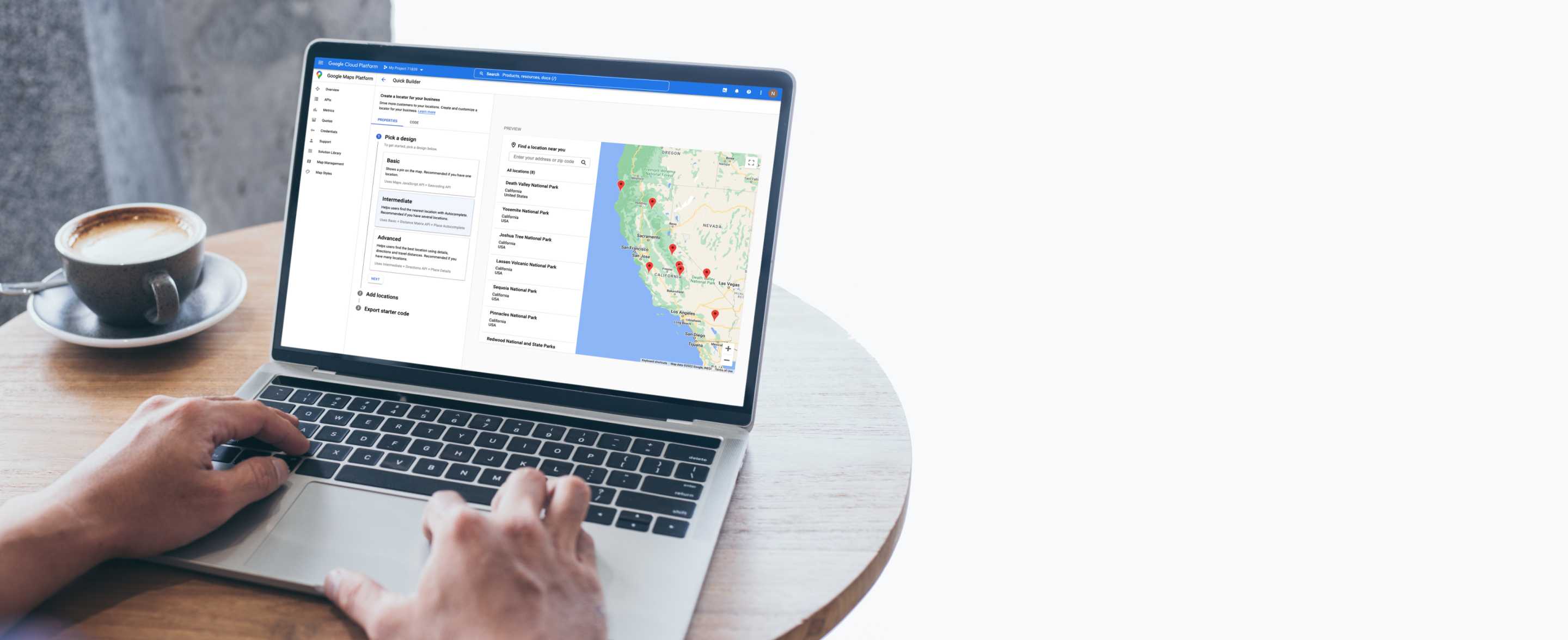
Trouver le lieu idéal
Aidez vos clients à trouver le magasin, le distributeur de billets, le restaurant, le garage ou le cabinet médical le plus proche (et bien plus).

Afficher l'adresse la plus proche
Ajouter des détails sur le lieu
Proposer un itinéraire
Highlight what’s nearby


Helpful features


Des produits conçus pour trouver le lieu idéal

2D Map Tiles
Concevez des interfaces et des interactions spécifiques à vos exigences de marque et de style, et personnalisez vos visualisations.
En savoir plus

Aerial View
Impressionnez vos utilisateurs avec des vidéos 3D cinématiques pré-rendues des points d'intérêt et de leurs alentours.
En savoir plus

Dynamic Maps
Personnalisez et appliquez un style à vos cartes interactives avec les styles de cartes basés dans le cloud, et profitez de mises à jour en temps réel sur tous vos appareils et plates-formes.
En savoir plus

Maps Datasets
Importez, stockez et gérez vos données géospatiales dans la console Google Cloud pour les utiliser avec les API Google Maps Platform.

Photorealistic 3D Tiles
Concevez des expériences immersives de cartographie 3D avec notre plate-forme de développement hautement personnalisable.
En savoir plus

Street View Tiles
Utilisez des images prises au niveau de la rue et des métadonnées de tuile pour créer des expériences performantes et immersives.
En savoir plus

Directions
Fournissez un itinéraire entre plusieurs lieux selon votre moyen de transport (voiture, transports en commun, vélo ou à pied).

Distance Matrix
Calculez les temps de trajet et les distances pour plusieurs destinations.

Autocomplete
Aidez les utilisateurs à trouver rapidement le lieu exact qu'ils recherchent en leur suggérant automatiquement des établissements et des points d'intérêt lorsqu'ils saisissent leur recherche.
En savoir plus

Geocoding
Convertissez des adresses en coordonnées géographiques, et vice-versa.

Geolocation
Renvoyez la position d'un appareil en fonction des données géospatiales des antennes-relais et des nœuds Wi-Fi, sans avoir besoin d'un signal GPS.

Nearby Search
Recherchez des lieux dans une zone spécifiée, avec la possibilité d'affiner la recherche par type de lieu.
En savoir plus

Text Search
Fournissez des informations sur un ensemble de lieux en fonction d'une seule requête de recherche et de n'importe quel lieu spécifié.
En savoir plus

Air Quality
Réduisez l'exposition des utilisateurs à la pollution de l'air grâce à des données et des insights sur la qualité de l'air.
En savoir plus

Pollen
Améliorez le quotidien des personnes souffrant d'allergies grâce des informations à jour sur différents types et niveaux de pollen.
En savoir plus

Solar
Utilisez des données et des images avancées pour créer de meilleurs designs et devis de panneaux solaires, tout en éliminant de coûteuses visites sur site.
En savoir plus

We wanted the app to help customers across the world find their most convenient eat-in, takeaway, drive-thru, partner store, or delivery platform, and highlight which services are available...Google Maps Platform has become integral to our digital operations. New features and capabilities of Google Maps Platform products have allowed us to continue innovating.
Gordon Lucas
Global Head of Digital Engineering, Costa Coffee

