Productos
Soluciones
Por caso de uso
Productos
Soluciones
Por caso de uso
Productos
Soluciones
Por caso de uso
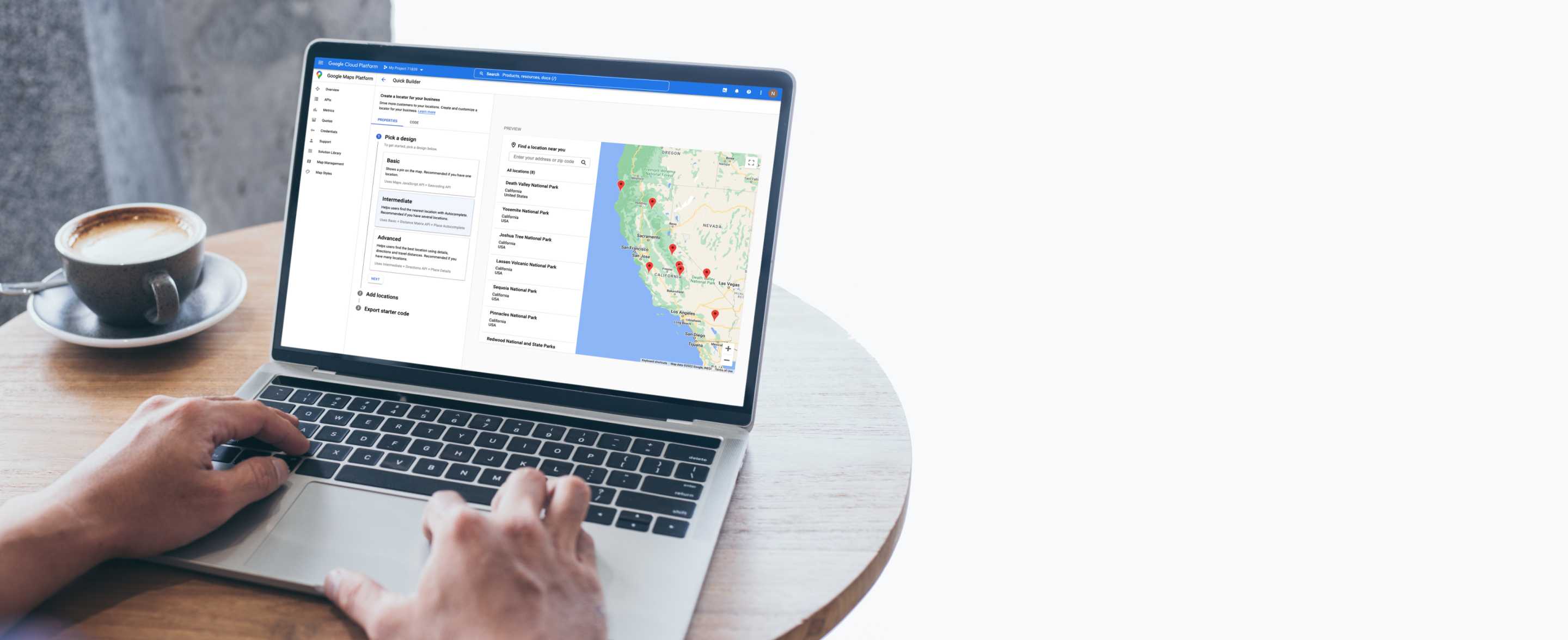
Casos de uso
Muestra la ubicación ideal
Ayuda a los clientes a encontrar la tienda, el cajero automático, el restaurante, el taller mecánico o el consultorio médico más cercanos, y a muchos lugares más.

Muestra la ubicación más cercana
Agrega detalles del lugar
Ofrece instrucciones sobre cómo llegar
Highlight what’s nearby


Helpful features


Productos diseñados para encontrar la mejor ubicación

2D Map Tiles
Diseña interfaces e interacciones únicas para tu marca y tus requisitos de diseño, y personaliza tus visualizaciones.
Más información

Aerial View
Deleita a tus usuarios con videos cinemáticos 3D renderizados previamente de lugares de interés y sus alrededores.
Más información

Dynamic Maps
Personaliza y aplica estilos a mapas interactivos usando el diseño de mapas basado en Cloud para mostrar actualizaciones en tiempo real en cualquier dispositivo y plataforma.
Más información

Maps Datasets
Sube, almacena y administra tus datos geoespaciales en la consola de Google Cloud para usarlos con las APIs de Google Maps Platform.

Photorealistic 3D Tiles
Crea envolventes experiencias cartográficas 3D con nuestra plataforma de desarrollo altamente personalizable.
Más información

Street View Tiles
Usa imágenes tomadas a nivel de la calle y metadatos de mosaicos para crear experiencias impactantes y envolventes.
Más información

Directions
Proporciona instrucciones sobre cómo llegar a múltiples destinos en transporte público, bicicleta, automóvil o a pie.

Distance Matrix
Calcula las distancias y la duración del viaje para varios destinos.

Autocomplete
Ayuda a los usuarios a encontrar rápidamente el lugar que buscan mostrando automáticamente sugerencias de empresas y lugares de interés mientras escriben.
Más información

Geocoding
Convierte direcciones en coordenadas geográficas o viceversa.

Geolocation
Muestra la ubicación de un dispositivo sin utilizar el GPS sino datos geoespaciales provenientes de torres de telefonía celular y nodos Wi-Fi.

Nearby Search
Busca lugares dentro de un área especificada con la opción de definir mejor la búsqueda por tipo de lugar.
Más información

Text Search
Proporciona información sobre un conjunto de lugares basada en una sola búsqueda y cualquier ubicación especificada.
Más información

Air Quality
Reduce la exposición de los usuarios a la contaminación del aire con datos y estadísticas de la calidad del aire.
Más información

Pollen
Mejora la vida diaria de quienes padecen alergias con información actualizada de diferentes tipos y niveles de polen.
Más información

Solar
Usa imágenes y datos avanzados para crear diseños y propuestas de paneles solares más avanzados y, al mismo tiempo, eliminar las costosas visitas a las instalaciones.
Más información

We wanted the app to help customers across the world find their most convenient eat-in, takeaway, drive-thru, partner store, or delivery platform, and highlight which services are available...Google Maps Platform has become integral to our digital operations. New features and capabilities of Google Maps Platform products have allowed us to continue innovating.
Gordon Lucas
Global Head of Digital Engineering, Costa Coffee

