Produkte
Lösungen
Nach Anwendungsfall
Produkte
Lösungen
Nach Anwendungsfall
Produkte
Lösungen
Nach Anwendungsfall
Anwendungsfälle
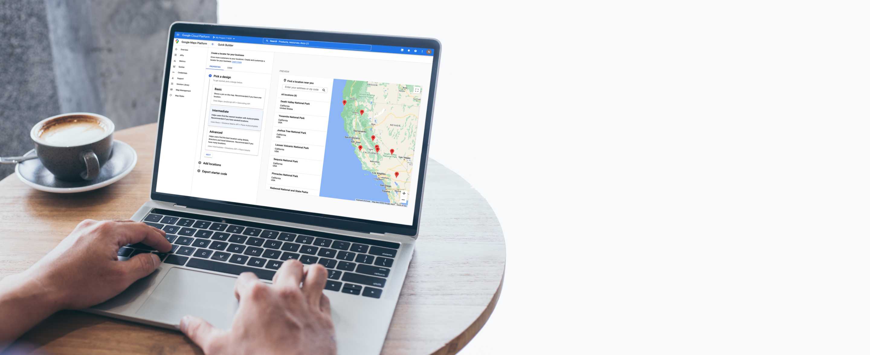
Den besten Standort präsentieren
Helfen Sie Nutzern bei der Suche nach dem nächstgelegenen Laden, Bankautomaten, Restaurant, Werkstatt, Praxis und mehr.

In der Nähe
Place Details hinzufügen
Wegbeschreibungen
Highlight what’s nearby


Helpful features


Produkte speziell für die Suche nach dem besten Standort

2D Map Tiles
Gestalten Sie maßgeschneiderte Benutzeroberflächen und Interaktionen für Ihre Marke und passen Sie Visualisierungen individuell an.
Weitere Infos

Aerial View
Mit vorab gerenderten 3D-Videos von POIs und ihrer Umgebung können Sie einen Kinomoment schaffen und Ihre Nutzer beeindrucken.
Weitere Infos

Dynamic Maps
Durch cloudbasiertes Gestalten von Karteninhalten lassen sich interaktive Karten entwerfen und anpassen, die auf allen Geräten und Plattformen synchronisiert werden.
Weitere Infos

Maps Datasets
Sie können Ihre Geodaten in die Google Cloud Console hochladen und sie dort speichern, verwalten sowie mit den Google Maps Platform APIs verwenden.

Photorealistic 3D Tiles
Erstellen Sie auf unserer Entwicklungsplattform eindrucksvolle 3D-Karten, die Sie individuell anpassen können.
Weitere Infos

Street View Tiles
Anhand von Bildern auf Straßenebene und Kachel-Metadaten können Sie immersive Karten mit umfassenden Funktionen erstellen.
Weitere Infos

Directions
Lassen Sie Ihre Nutzer wissen, wie sie am besten von einem Ort zum anderen kommen – mit öffentlichen Verkehrsmitteln, dem Fahrrad, dem Auto oder zu Fuß.

Distance Matrix
Mit dieser API können Sie Fahrtzeiten und Entfernungen für mehrere Ziele berechnen.

Autocomplete
Helfen Sie Ihren Nutzern, schnell genau den Ort zu finden, nach dem sie suchen – mit automatischen Vorschlägen für Unternehmen und POIs während der Eingabe.
Weitere Infos

Geocoding
Wandeln Sie Adressen in geografische Koordinaten um oder umgekehrt.

Geolocation
Mithilfe der Geodaten von Mobilfunkmasten und WLAN-Hotspots lässt sich auch ohne GPS der Standort eines Geräts angeben.

Nearby Search
Nutzer können nach Orten innerhalb eines bestimmten Bereichs suchen – mit der Möglichkeit, die Suche nach Ortstyp zu verfeinern.
Weitere Infos

Text Search
Anhand einer einzelnen Suchanfrage und eines angegebenen Standorts werden Informationen zu verschiedenen Orten angezeigt.
Weitere Infos

Air Quality
Mithilfe von Daten zur Luftqualität lässt sich die Belastung durch Luftverschmutzung verringern.
Weitere Infos

Pollen
Aktuelle Informationen zur Art und Intensität der Pollenbelastung helfen Allergikern im Alltag.
Weitere Infos

Solar
Mit noch detaillierteren Daten und Bildern lassen sich bessere Entwürfe und Angebote für Solaranlagen erstellen – auch ohne direkt vor Ort zu sein.
Weitere Infos

We wanted the app to help customers across the world find their most convenient eat-in, takeaway, drive-thru, partner store, or delivery platform, and highlight which services are available...Google Maps Platform has become integral to our digital operations. New features and capabilities of Google Maps Platform products have allowed us to continue innovating.
Gordon Lucas
Global Head of Digital Engineering, Costa Coffee

